American Indian Reservations in Nevada
The Shoshone Paiute Tribes of the Duck Valley Indian Reservation – "The Tribes once freely occupied the lands of their forefathers and foremothers in the tri–state area of what is now Idaho, Nevada and Oregon. This however quickly changed at the coming of the populations of Europe. Lands and resources were wrestled away from the Shoshone and Paiute. Treaties were made with the United States of which some were ratified and others not. The chiefs signed all the treaties in good faith and for the survival of their people. Descendents of the Western Shoshone and the Northern Paiute occupy the Duck Valley Indian Reservation of Idaho and Nevada. Various bands of the two closely related tribes have jointly utilized the area from time immemorial. . . . Farming and Ranching are still mainstays for Duck Valley and is reflected in the 12,000 acres of subjugated lands. The Duck Valley Indian Reservation is composed of 289,819 acres held in trust by the United States Government for the use and occupancy of the Shoshone–Paiute Tribes. Wildhorse Reservoir was constructed in 1936 for the Duck Valley Irrigation Project. Tribal membership is over 1800 with approximately 1200 living on the reservation. The Shoshone–Paiute Tribes of Duck Valley continued to exist within the original territories of their ancestors. Shoshone Paiute Business Council, Owyhee, NV.
Duckwater Shoshone Tribe - "The Duckwater Shoshone Tribe is located in beautiful Railroad Valley, a remote, high desert valley in the very northern tip of Nye County. The Tribe is primarily an agricultural community, drawing water from the largest geothermal hot spring located in the State of Nevada. . . ."
Confederate Tribes of the Goshute Indian Reservation -"We are descendants of the bands of Indians who settled in Eastern Nevada and Western Utah. The Shoshone-Goship people have always been an integral part of Western Utah and Northeastern Nevada. The word Goshute (Gosuite) is derived from the native word Kutsipiuti (Gutsipiuti) which means 'desert people'. We have inhabited the land long before the arrival of the white man in America." The postal address is Ibapah, Utah.
Fort McDermitt Indian Reservation - 689 enrolled members in 1992. The reservation spans the Nevada–Oregon border in Humbolt County, Nevada and Malheur County, Oregon. - wikipedia
Moapa River Reservation -" The Moapa Band of Paiute Indians resides on the Moapa River Reservation. We are a recognized Indian tribe organized under a Constitution approved by the Secretary of the Interior on April 17, 1942. The tribal lands originally set aside in 1874 consisted of two million acres, but in 1876 it was reduced to a thousand acres. In December 1980, under the Carter Administration, an additional 70,000 acres were provided. The current total land base is 71,954 acres. . . ." The business office is in Moapa.
Fort Mojave Reservation - "Mojave Indians are Pipa Aha Macav – 'The People By The River.' Mojave culture traces the earthly origins of its people to Spirit Mountain, the highest peak in the Newberry Mountains, located northwest of the present reservation inside the Lake Mead National Recreation Area. . . .The Fort Mojave Indian Reservation is located along the Colorado River in the vacinity of Needles, California. The Reservation covers nearly 42,000 acres in the tri-state area of Arizona, California, and Nevada. The land is divided into three major segments: 23,669 acres in Mojave County Arizona; 12,633 acres adjacent to Needles, California; and 5,582 acres in Clark County, Nevada. Tribal headquarters are located in Needles, California."
Pyramid Lake Indian Reservation - "In 1993, reservation residents numbers were 1,603 individuals, 802 males and 801 females. 45% of the population resides in Wadsworth, Nevada; and 15% of the population resides in Sutcliffe, Nevada. The Pyramid Lake Paiute Tribe has approx. 2,253 enrolled members. . .The area of the reservation contains 475,000 acres or 742.2 square miles. Out of this acreage approximately 112,000 acres cover the surface of a terminal desert lake, Pyramid Lake." Administrative Office is in Nixon.
South Fork Indian Reservation - Te-Moak Tribe of Western Shoshone Indians of Nevada, Elko. "The South Fork Reservation covers approximately 13,050 acres in northeastern Nevada, 28 miles south of the city of Elko. The reservation sits on rugged high desert terrain typical of northern Nevada and Utah. It is located just west of the Humboldt National Forest and in the foothills of the Ruby Mountains. The South Fork Reservation was established by Executive Order in 1941 under the provisions of the 1934 Indian Reorganization Act. Land purchases between 1937 and 1939, totaling 9,500 acres, were put toward the newly established band's land base. Subsequent land purchases brought the Reservation to its present size. . .The South Fork Reservation is one of four separate bands that comprise the Te-Moak Tribe of Western Shoshone Indians. The South Fork Reservation was one of the groups of Western Shoshone that refused to move to Duck Valley and remained living at the headwaters of the South Fork area of the Humboldt River at the base of the Ruby Mountains, until lands in that area were purchased for them in 1937." Federal Reservation, Elko County; office, Spring Creek.
Summit Lake Pauite Tribe - Administrative Office, Sparks, NV, 89431.
Walker Indian Reservation - "The Walker River Paiute Tribe is a federally recognized Tribe in Nevada. Our reservation was established in 1874 by Executive Order and is under the General Allotment Act of 1887. Before that time, the original Agai-Dicutta 'Trout Eaters' Paiute were to be displaced along with other Bands to the Pyramid Lake Reservation. . .The Walker River Paiute Reservation is located within three counties in rural Midwestern Nevada about 100 miles southeast of Reno, Nevada with the population of over 1200 residing within the boundaries of the Walker River Paiute Tribe. The land base consists of about 325,000 acres in a river valley, mostly used for grazing and some ranching. The present Reservation encompasses a high desert land base and is surrounded by mountains, desert lakes, and marshland/wetlands." The Administrative Office is in Schurz.
Indian Tribes of the United States at accessgenealogy
Indian Census Rolls at accessgenealogy
Native American Land Patents at accessgenealogy
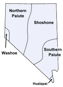
(Map from Native Languages)
Indian Tribes of Nevada at accessgenealogy.com
Indian Census Rolls 1885-1940, at accessgenealogy
Updated March 20, 2015
Broken Links? Suggestions? Want to get involved? contact Sharon McConnel, Administrator
Happy Researching!

The background tartan in the footer logo is the Nevada State Tartan, adopted in 2001.
The American History and Genealogy Project (AHGP), an unincorporated not-for-profit network of independent sites devoted to History & Genealogy, and covering North American Countries and Territories. For more information about our group, including how you can join us, please see our About page.
Webspace for this site is generously provided by Genealogy Village and Access Genealogy
Copyright © 2014 - Sharon McConnel. All Rights Reserved.